
Map Shows Bird’s-Eye View of Danbury in 1934
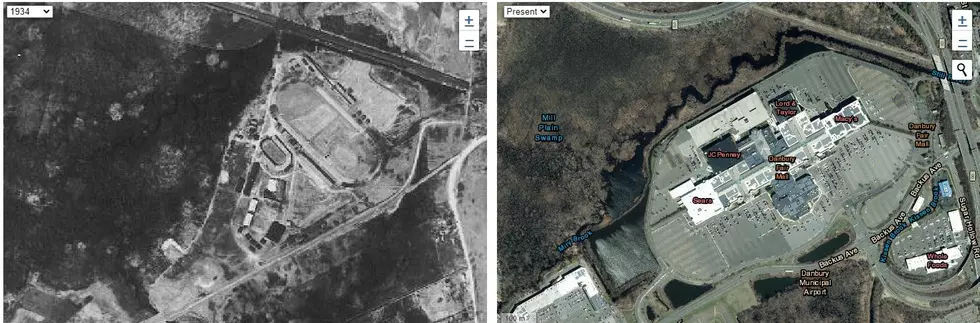
I just discovered an interactive map project from the University of Connecticut called MAGIC, and..it's magical. Basically, what this interactive map does is show you side by side aerial photographs of our state from different years. The most stunning setting on MAGIC is comparing what 1934 Connecticut looks like right next to present day Connecticut.

88 years is a long time, and as far as how the geography of Connecticut has changed in all of those years, it's absolutely stunning to see how some of our cities and smaller towns have grown.
I took a look around at some Danbury landmarks using the University of Connecticut Library's MAGIC, which stands for Map and Geographic Information Center, and it's amazing to see how the Greater Danbury area has changed, especially in downtown and Newtown Road. Take a peek at these photos.
Interactive Map Shows You A Bird's Eye View of 1934 Connecticut
The University of Connecticut Library's MAGIC program is focused on "Digitizing the past to empower 21st century research". What I like to think of it is a tool for your grandparents to say "See! That's where the old Horsey farm used to be." It's cool to see how much has changed in our home state in 88 years. You can also compare aerial shots from 1990 and 2004 to the present day using MAGIC. Have some fun with it, it's free.
MTV's Fear At St. Agnes Hospital for the Chronically Ill - Fairfield State Hospital
Cinnamon Churros to Sweeten Up Bethel
More From 105.5 The Wolf


